November 30, 2016

Walking in the Entlebuch UNESCO Biosphere

November 30, 2016 -- Still time for some late fall / early winter hikes, we just have to find the low places that are not sitting in the fog.

The Entlebuch UNESCO Biosphere is a 400 sq.km area of "unspoilt moorlands and idyllic Alpine pastures" West of Lucerne. It is Switzerland's only biosphere reserve and there are strict regulations as to what changes (construction, population, etc.) are allowed to be made to this area to conserve the landscape and environment.

We lucked out with lovely warm sunshine especially after climbing up the hill and walking across the ridge. Even in some of the shady areas where the morning frost no longer thaws, it wasn't too cold. 

And since this is close to the Kambly cookie factory, we celebrated another 12-km hike by visiting the cookie store to sample their Christmas offerings, and purchase some too, of course!


We started our hike in the valley at Schüpfheim and walked up to the low ridge, only 300 altitude meters, which I can do fairly easily now.

This is a typical house of the Entlebuch region.

And this is the best kind of Swiss dog, although a bit big for my taste.

The cows are off the pastures now and in the barns, but they have access to the outside and also enjoy a bit of sunshine.

Early winter sun still warms the pastures a bit.

The entire area consists of low hills dotted here and there with farmsteads and chapels. Very few villages and no real cities.

The low rolling hills and pastures are dotted with farmsteads and pastures.

After reaching the ridge, we decided this was a perfect place for our picnic lunch.

After reaching the ridge, we decided this was a perfect place for our picnic lunch.

As long as we were on the South side of the ridge, we had sun. But we still walked quite a bit through forested areas.

Enjoying some early winter sunshine in the Entlebuch.

Lovely views into the Entlebuch Valley.

This is the view North from the ridge (Fontannen Valley).

This is the view Northward from our ridge. Some of the pastures get no sun anymore at this time of year.


We passed a farmstead where all the cows were indoors, but when they heard us talking, all these cute babies poured out to greet us.

Heading down to our goal, the town of Entlebuch where we will catch the train to the Kambly cookie factory.


In Trubschachen is the Kambly Cookie Factory. They have a store at the far end, where you can sample as many cookies as you like. The first time I did this, I got sick. Now I know to limit the intake!


Our 12-km, 3 1/4-hour hike from Schüpfheim to Entlebuch across the ridge.

November 23, 2016

On our Local Mountain, Mount Zug

November 23, 2016 -- In the Alps there is a weather phenomenon called a Fön Wind, which blows warm air from the South over the Alps, which is the case right now, and all the lovely snow the mountains got at the beginning of November is pretty well gone or just not so nice any more.

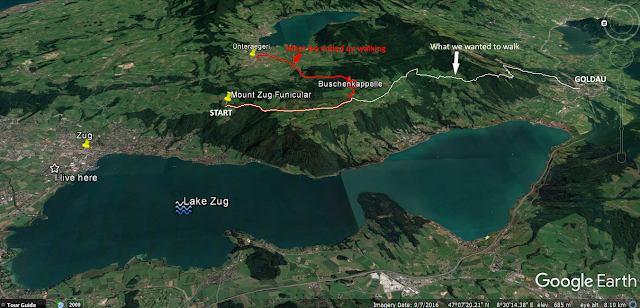
This Fön Wind can blow up to 120 km per hour and we were not at all expecting it up on our local small mountain, Mount Zug, as we took the Funicular up the hill with the plan of hiking across the range for four hours to Arth-Goldau on the South end of Lake Zug. (This is something I have been wanting to do for a long time now, having lived here over three years and usually traveling much further away for our hikes.)

We stuck it out for an hour, but the strong South wind (maybe about 70 km/hour) hitting us from the front made walking tedious, so we changed plans and headed Northeast to Lake Aegeri on the East side of Mount Zug. At least the wind was behind us. And even though I will have to reschedule my goal to hike across Mount Zug, we got in another good 10km of afternoon exercise! 

Heading up Mount Zug with the Funicular

View of the North end of Lake Zug from Mount Zug

Walking against the South wind was tedious, and I wasn't ready to do another 3 hours of this.


After walking for a little over an hour, we escaped into the little Buschenchappeli (Chapel) to have a bite to eat (no photo, all I had on my mind was escaping the wind) then headed NE down the other side of the mountain with the wind at our backs.
Landscape on Mount Zug, our local hills, looking North. 
Approaching Lake Aegeri


This little chapel in the middle of a farmstead is called the Antonius Chapel, built in 1671. This is along the pilgrim trail from Walchwil to Einsiedeln. 

In Aegeri we are going to catch the bus back home.


Church in Unteraegeri (Lower Aegeri)

Our plan and change of plan, because of strong South Winds

November 20, 2016

The Bachtel Tower Viewing Platform near Zurich

November 20, 2016 -- There has been some snow, but it has melted a lot, unfortunately leaving many of the forest trails wet and muddy. Nevertheless, it is still great to be able to do a 15-km walk with sunshine and crisp views of the entire Alp chain all the way to the Bernese Alps.

Just East of Lake Zurich are rolling hills which are popular for hiking because it's not too far for the city people to travel to. There are also several towers with look-out platforms, easily accessible both on foot and by car. On Sunday we chose one of these hills (Bachtel) with a look-out tower as our first stop because there was a restaurant (1-hour uphill walk) where we had our Sunday lunch, before continuing on for 3 more hours to our destination of Steg back in the valley bottom. 15 km in 4 hours, 15 mins.

Heading up to Bachtel Tower and Restaurant for lunch

Passing some pretty farm houses along the way.

View on our ascent, not yet sunny but crisp mountain views.

Looked cool.

Arriving at the top near the Bachtel Tower. Before going up the tower, we will have lunch in the restaurant (to the left off the picture).
Heading up to the viewing platform on the Bachtel Tower: 180 steps....
 
Heading up to the viewing platform on the Bachtel Tower: 180 steps....

View of Lake Zurich to the West, and the Bachtel Restaurant below, where we had lunch.

Zoomed photos of the Central Alps: Mythen x2 upper left, Eiger/Jungfrau upper right.
To the NW, lakes Pfäffikersee and Greifensee
To the North is the landscape we are now going to walk for 3 hours before descending into the Töss Valley on the right.

It snowed up here a couple of weeks ago, and the melting snow has left the paths pretty muddy.

The afternoon sun was pleasant, just right for this hike.

View South to the Glarus Alps


Total distance from Wald to Steg approx. 15 km, in 4 hours 15 minutes. 


November 12, 2016

To the Top of Monte San Salvatore

Saturday, November 12, 2016 -- As of about a week, there is lots of snow at elevations above 1000m, so until the winter walking trails are officially prepared, we are relegated to flatland hikes to the North, or steeper mountain hikes way in the South, in the Ticino, where we like to go anyway, and where as of December 11th with the official opening of the new Gotthard Base Tunnel to public transportation we will be able to get there in way less time, so YEAH!

On this Saturday we traveled to Lugano to climb the "House Mountain" Monte San Salvatore. We usually don't climb, but take cable cars or funiculars if possible, but this was something I wanted to tackle (funicular isn't running in winter anyway) and since the climb was on the shady side of the mountain, we walked fast to keep warm and made the summit (600 altitude meters) in 1.5 hours instead of the 2 hours it usually takes.... (more below)


Monte San Salvatore is the pyramid-like peak in the center, as seen from Monte Brè. This is basically the same lighting we had on today's hike.

The start of the hike is along the funicular tracks. We were on Monte Brè in Jan.2016.
From this vantage point, Monte San Salvatore doesn't look so high!

On the way up the only sun we got was on the East Side of the Mountain.

On the way up the only sun we got was on the East Side of the Mountain.

Once we got to the top, there were several look-out points from which one could alternately see the entire Lugano Lake basin, the Italian Alps, and all the way to Canton Valais in the West to the Monte Rosa Massif, where the highest peak in the Swiss Alps (Dufour Peak, 4,634 metres (15,203 ft)) is located. 

Very windy look-out point NE to Monte Brè and the Italian Alps to the East

To the West, the Monte Rosa Massif in Canton Valais, with the highest peak (Dufour Spitze) in the Swiss Alps.


At this lookout point, we stopped for our picnic lunch (out of the wind)

At this lookout point, we stopped for our picnic lunch (out of the wind)

At this lookout point, we stopped for our picnic lunch (out of the wind)

This is the view from the spot we stopped for our picnic lunch

This is the official summit of Monte San Salvatore, with the first of six Churches along the "Trail of 6 Churches"

View South along Lake Lugano. We are very close to the Italian Border here.

View South along the San Salvatore Ridge, where we will continue our hike. 

From here we walked South across the ridge through a couple of villages, and instead of ending our hike in Carona (there is a bus there) at the top, we decided to finish the 6-Church Trail by descending on the West of the ridge to the valley below, to catch the bus back to Lugano. In total it was a 14 km hike in just a little over 4 hours, with lots of sunshine, but at this time of year, the shadows hit early in the valley bottoms, so we basically have to finish our hikes by 4 pm. 


14-km hike, 600 altitude meters, 4 hours


Much of the rest of our hike is through woods, with a few clearings and a couple of villages.

Much of the rest of our hike is through woods, with a few clearings and a couple of villages.

This little village of Ciona has the second oldest church on the 6-Church Trail.
Several of the buildings in Ciona had working sun clocks! And a lizard heading for shelter on the wall.

In the village of Carona, we stopped for Macchiato, and decided to keep hiking on the 6-Church Trail

In the village of Carona

The six churches on the "Trail of 6 Churches"

(Along the 6-Church Trail, these are the six churches in the order we saw them: 1. Monte San Salvatore, 2: Ciona, 3: Church on North side of Carona, 4: Santa Marta on Carona village outskirts South side, 5: Madonna d'Ongero in the middle of the forest South of Carona, 6: Torello, in a clearing on the way down the mountain to Figino)


Church at Torello just above Figino

Church at Torello just above Figino

Nearing the valley bottom on the West side of the San Salvatore Range

One more church in the valley bottom... for good measure

And one last view of Monte San Salvatore, which still has sun although we are already in shadow